Region: AB, Kananaskis Valley
GPS Elevations: Mist Mountain 3130m (10,269ft), Mount Lipsett 2582m (8471ft)
Difficulty: 4th class
Style: Solo
Total Ascent: 1538m
Distance: 15.4km
Moving Time (Moving Average): 5h15 (3.1km/h)
I had spent a week in Canmore with the goal of acclimatizing my legs before spending another week in the Purcells. It’s hard to get big elevation days around Montreal (e.g. I found 6 laps up Mont Royal logged around ~800m) so I had planned a week around Canmore to do some proper outings prior to the actual plan of going to the Purcells. In the prior week I had already done a couple long traverses (see <insert-link> & Bald Eagle Peak, Buffalo Point, Lady MacDonald Traverse) so for my last day around Canmore before moving on to BC I was thinking something more casual would be in store, such as visiting the Mist Mountain spring (was advertised at the hostel I was staying at) and figured if the soak was replenishing enough and weather cooperated enough (afternoon rain was forecasted for Canmore) I’d try to bag Mist Mountain while in the area. Well, at least that was the plan…
This would be my first trip into Kananaskis Country (or as I learned “K Country”) and with Mist Mountain being pretty far down (South) from the highway I got to enjoy scoping out several nice peaks on the drive in. The downside to being green to this region was that I didn’t have good instructions on parking and took what appeared to be the first obvious place to park given all the other cars already there and more people pulling in. However, after about an hour on the trail I started emerging from the trees and noticed the ridgelines around me we not where I was expecting them and a quick look at the GPS indeed confirmed I was not on the right trail. Instead of walking towards the spring I was heading towards a Mount Lipsett.


I had a rendez-vous back in Calgary later in the day such that I needed to be back on the road by around 17h00, and since this was my intended rest day outing I was already on a late start (left the lot around 10h00). So hiking back out and looking for the correct trail head wasn’t really an option if I wanted any chance of doing Mist. Also, I recalled reading in Kane’s book about a harder scramble option from the Mist-Lipsett col, so that became my new objective and the soak in the spring would just have to wait 🙁
The hike up Mount Lipsett was a straight forward trail and, in hind sight, all the families I passed along the trail ought to have been an early indicator that I wasn’t heading towards the spring. If I wanted to be out in time and have room for a soak I figured I’d need to summit Mist no later than 14h00 and so book it up the trail to Lipsett to bag that peak no later than noon. I had a good view of the scramble up Mist at this point and figure 2 hours was doable if I didn’t get cliff’d out too many times (Kane’s guide did warm of steep ribs along this route that forced back tracking). So I kept a good pace and was at the top of Lipsett by 11h50


Left: Lipsett summit register. Top-Right: View of the North Ridge which according to Kane’s guide is the more common scramble route. Bottom-Right: View of the Mist-Lipsett col and the scramble I’m targeting which, if all goes well, will connect me to the South Ridge near the top.
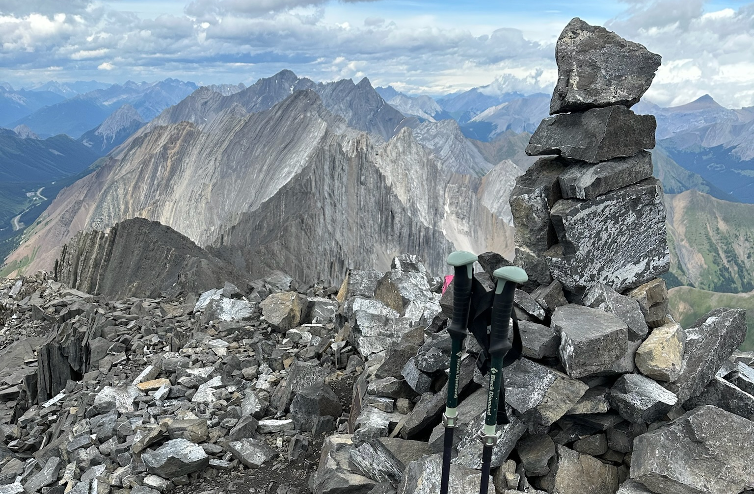
The elevation lost to the col was pretty minimal, but the scree slog up to where the scrambling starts on the other side of the col was definitely the worst of the loop (steep, soft, and loose). A sort of one step back for every two steps forward scenario and I was glad to have my poles. However, once I reached the scrambling on Mist it started off with pretty nice rock (seemed nicely water worn). And even higher up there were many places to choose steeper rock versus loose scree, but the overall quality of the rock and scramble definitely deteriorated as I got closer to the South ridge. Nearer the top I also strayed NW a little too much (following better quality rock) and did indeed get cliff’d out (the steep voids between ribs on the NW side are a sure way to meet your maker), but was able to traverse back SE to re-align my trajectory towards the South ridge without really back tracking, albeit this also added some pretty exposed 4th class climbing to the route. Once connected with the South ridge, it was a pretty standard scree slog for most of the remaining terrain, which got a lot easier after intersecting a more beaten path near the summit. When I checked the time it was 13h50, 10 minutes to spare! Needless to say, I didn’t stay for long.

Interesting fact on Mount Swiderski
Did not see a first ascent until 2005! Apparently it was the last named peak to remain unclimbed in the Southern Rockies until this time. Finally submitting to the party of Rick Collier, John Holmes, and Martin Taylor.


The descent down the Southern slope was actually pretty accommodating scree for heel plunging and almost dry-glissading at times. I lost elevation rapidly and once down in the drainage and picked a fairly arbitrary spot to cut off from the well defined descent trail and head over the creek towards the spring. I did this because I saw that following the normal trail would mean loosing more elevation than necessary. By cutting across early I was able to approach the springs from above and then descend basically right next to them. It was around 15h00 when I reached the springs and although I had read about two pools there was only one in sight with a couple people already in it, and a couple other people in queue. The people there had also heard about a 2nd pool but their searches around the area didn’t find anything. So I waited a bit for my turn to dip and was eventually received by what I would describe as less then luke warm water. Wasn’t exactly rejuvenating, but still better than the cold dip you’d find pretty much anywhere else along a hike. By the time I got out the sun was gone and wind was out so it was a cold air dry before heading back out.


My timing for leaving turned out to be pretty good. I was back on the trail around 15h30 and shortly after that it started raining. I also crossed several groups of people on their way to the spring so it seems late afternoon is a popular time for a soak there. The hike out also provided a lot of nice greenery on the hills, and I got the feeling this was a bit of a trait for K-Country.

I exited at the trail entrance for the spring, which was a pretty ill defined location along the highway, marked by a flag on a small pine. I had to hike West beside the highway a short ways to get back to my car at 16h45. Not bad, 15 mins to spare before my 17h00 cut-off! Really not the “rest” day I was planning but none-the-less a very pleasant day out with a bonus peak bagged en route. The routes described in Kane’s book seem like they’d be much shorter (they approach from the North or West of Mist), but I think my loop is actually a pretty good option for any scramblers wishing to visit the spring as it lies to the SW of Mist. I’ve shared a image of my GPS tracks, but not the actual file as I wouldn’t want to encourage anybody to follow my footsteps from the col as there is certainly a safer path than what I did.

